-40%
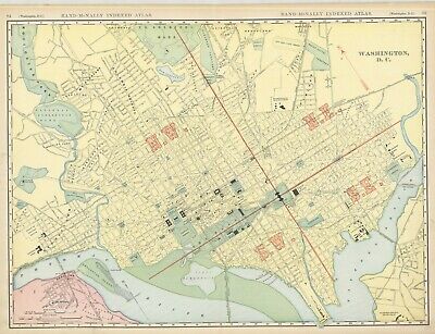
c1898 District of Columbia---The Nation's Capital
$ 14.25
- Description
- Size Guide
Description
Pacific Shore Maps.San Diego, California.
Original,collectible (and sometimes Rare) maps & prints
Title:
Washington D.C.
Cartographer: Rand
McNally
& CO
Time and Place: c1898; Chicago
Publisher: Rand
McNally
& Co.
Reference:
Rand
McNally
Indexed Atlas
Dimensions & Type: 19 x 25, colored lithograph
Condition: VG+, clean example, full litho color.
Description:
Very large
format
map
from
an Atlas
meant
mostly
for
Businesses
and
Libraries. North offset slightly to the upper left. Small section of Virginia shown (Rosslynn and "Ft. Myer Heights"). Very detailed. Attractive enough to frame , informative enough to be used for research. In NE is the "Ivy City Race Track" (appropriately adjacent to the Mount Hope Cemetery) and a neighborhood named "Metropolis View". The New Union Station is "now under construction".
Shipping cost slightly higher as this is an oversized item (tubed)
Also visit “mapseller01” or Google “Pacific Shore Maps” for more cartography


